
Clearfield ZIP Code Directory Coverage
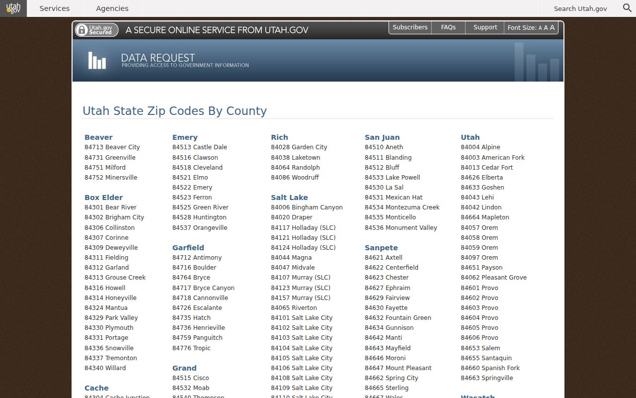
Four ZIP labels matter in Clearfield research, but they do not all mean the same geographic thing. The Utah ZIP-by-county table lists 84015, 84016, and 84089 with Clearfield labels. USPS materials identify a Clearfield Post Office at 98 North Main Street for 84015, and the state or health-area material also places 84056 in a Clearfield-area grouping. The Davis County crosswalk is more precise about the municipal mismatch: 84015 includes Clearfield, Clinton, Sunset, and West Point.
| ZIP | Areas or label | Post office or station | Research note |
|---|---|---|---|
| 84015 | Clearfield plus parts of Clinton, Sunset, and West Point | Clearfield Post Office, 98 N Main St; Freeport Center station nearby | Shared ZIP, not city limits |
| 84016 | Clearfield-labeled area | Clearfield label in official table; station not verified | Use as postal filter, then confirm parcel city |
| 84056 | Hill Air Force Base area | Hill AFB Post Office, 7338 Loncki St | Installation postal geography, not Clearfield city |
| 84089 | Clearfield-labeled west or north service geography | Clearfield label in USPS table | Confirm the incorporated city in GIS |
The Clearfield Post Office listing gives phone 801-779-9110 and hours Monday through Friday 8:30 to 5:30 and Saturday 8:30 to 1. Nearby Freeport Center is at 391 East 1700 South. These are postal service points, not records offices. A ZIP code directory should retain the source label every time it says “Clearfield.”
Clearfield ZIP Code Directory and 84015
84015 looks like a Clearfield shortcut, but the official Davis County city-by-ZIP crosswalk assigns it to multiple municipalities. A person or parcel found with an 84015 mailing label may fall outside incorporated Clearfield. Conversely, a city record can use an address field that does not match the postal label a researcher expected. This is why a ZIP search should not be treated as a citywide resident list.
Use three labels in your notes: postal city and ZIP, incorporated city, and county or health-service area. The health materials group 84015, 84016, and 84056 as a Clearfield Area, but that grouping is not a municipal boundary. The 84056 label belongs to Hill Air Force Base. A map check is the clean way to distinguish postal service from parcel geography.
Confirm the state’s ZIP-by-county listing at the Utah ZIP code table.
Find a Person Using the Clearfield ZIP Code Directory
A ZIP code can be a useful narrowing clue, but the available portals do not all accept it in the same way. Utah Voter Information accepts ZIP with a name, date of birth, street, and city. Davis Property Search accepts a property address or parcel and lets the researcher browse a map, but no ZIP-wide bulk filter was exposed in the public interface. UGRC parcel services can carry address and parcel attributes in a data-service context. USPS is the source for delivery geography, not a resident roster.
- Verify the ZIP and postal city with USPS, especially if the result is 84015 or 84056.
- Use the person’s name, street, city, and ZIP in the Utah Voter Information form.
- Use the same address in the Davis County map, select the parcel, and save Parcel ID, Legal Description, situs, and mailing fields.
- Compare the postal label with the incorporated city shown by county GIS.
- Once a ZIP narrows the question to a street, continue with the Clearfield street directory address chain.
This sequence avoids trying to manufacture a ZIP-wide resident list from a person-level form. A voter result is a public registration lead. A parcel result is property evidence. Neither one contains every person who receives mail at the address.
Clearfield ZIP Code Directory USPS Fields
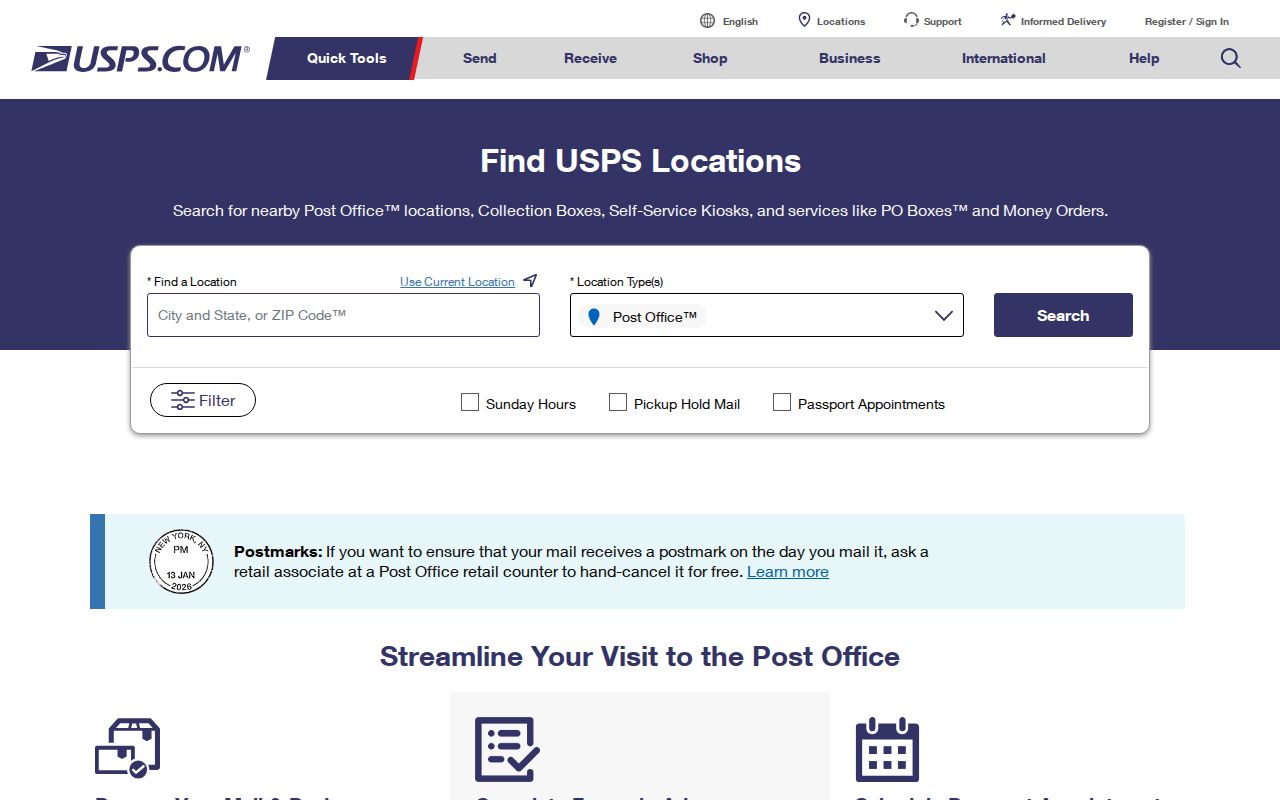
The USPS locations tool is the right place to check a post office, collection box, retail point, or other delivery facility near a ZIP. It accepts a street address or a city or ZIP code, with state selection. Filters include location type, Sunday Hours, Pickup Hold Mail, Passport, distance, and sort order. Distance choices run from 1 to 100 miles, and results can be sorted by distance or location type.
| City or ZIP Code | Enter Clearfield or a ZIP as the postal search key. |
|---|---|
| Location Type | Post Office, National Retailer, Collection Boxes, Contract Postal Units, kiosks, gopost, VPO, or All. |
| Distance | 1, 3, 5, 10, 20, 50, or 100 miles. |
| Sort | Distance, Location Type A-Z, or Location Type Z-A. |
| Filters | Sunday Hours, Pickup Hold Mail, and Passport. |
USPS also explains standardized ZIP and ZIP+4 use, while Postmaster Finder can search From ZIP and To ZIP or the first three digits and show established or discontinued information. No official Clearfield ZIP split or realignment year was located. Treat historic ZIP boundaries as a separate research question and confirm them with USPS or postal records.
Use the USPS locations search to test a Clearfield ZIP and filter a facility type.
Clearfield ZIP Code Directory Parcel Check
The Davis County Property Search map accepts an address or parcel ID, centers on a polygon, and exposes Parcel ID, Legal Description, and a tax link. Click adjacent polygons to see how the block falls across parcels. The county map is a better municipal check than a ZIP label because its geometry identifies a physical parcel and its county context. Utah Geospatial Resource Center parcel documentation lists fields such as PARCEL_ID, SERIAL_NUM, PARCEL_ADD, PARCEL_CITY, TAX_DISTRICT, ACRES, SUBDIV_NAME, and BUILT_YR in relevant layers, though the current application may expose a different set.
Keep situs, mailing, and postal fields distinct. Situs is the physical parcel; mailing is where tax correspondence goes; postal city and ZIP describe delivery routing; legal description is the title geography. The parcel ID is the strongest bridge into deeds and permits. A tax mailing address can be elsewhere and is not automatic proof that the named owner lives at the parcel.
Clearfield ZIP Code Directory Terms
- ZIP code
- A five-digit postal routing area. It can cross city boundaries.
- ZIP+4
- An added four-digit delivery segment that narrows routing inside the five-digit ZIP.
- PO-box ZIP
- A postal designation used for box delivery or a specialized facility, not a residential city boundary.
- Unique ZIP
- A ZIP assigned to one large institution or installation; 84056 is the local military-installation example.
- Carrier route
- A delivery route nested inside postal geography. It is not a public household directory.
These terms explain why a ZIP code directory must describe source and purpose. A USPS result answers where mail service is offered. A county parcel card answers where land is mapped. A voter form answers whether a supplied person-and-address combination matches released public information. Combining them without labels creates false precision.
Clearfield ZIP Code Directory Historical Research
Current ZIP labels do not establish the label used in a past directory, newspaper, deed, or letter. For an older Clearfield address, preserve the original street, city, and ZIP exactly as printed. Search USPS Postmaster Finder for established or discontinued information, then compare the address with a directory year, Davis County parcel or plat, and any known street change. No official source in this research verified a Clearfield ZIP split or realignment timeline.
For a historic household, the postal clue is only one part of the trail. The 1967 Clearfield city directory, the Davis County Clipper archive from 1892 to 1992, census pages released through 1950, and Recorder legal descriptions can date a place without assuming that a present ZIP existed in the same form. A later ZIP is not evidence that an earlier resident used that label.
Boundary note. ZIP geography is a delivery system. Confirm an exact Clearfield parcel in Davis County GIS before describing a ZIP result as a city result.
Clearfield ZIP Code Directory Limits
There is no verified public Clearfield ZIP-wide resident export in the named portals. The Utah voter file has a separate request channel, fees, availability windows, and protected-voter exclusions. The county Property Search map can be browsed parcel by parcel, but no public bulk ZIP filter was exposed. Court XChange uses court and county scope, not ZIP. Business and DOPL systems use name, city, profession, entity, or license fields. Each is a different research tool.
Use ZIP information for a postal clue, a facility search, a person-level match, or a parcel cross-check. For personal lawful research, do not use a postal label to stalk, harass, intimidate, or harm any person. Protected addresses, motor-vehicle data, utility records, and unlisted household details remain outside this directory approach.